Links and More Home
My Equipment
My Links
My Photos
My Training
My Tours
My Trips
Thursday 09/08/05
It was 8:00 am when I finally woke up and rolled off of the sleeping pad. I had unzipped the sleeping bag during the night and just laid it over me like a blanket. I laid there not needing to get up yet so I went back to sleep until 9:00 am and then finally got up.
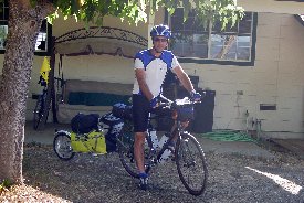
Most everyone had already started their day and it was time to start mine. I packed up my hear and went to the kitchen for breakfast. Cold cereal was on the menu for today. Connie and I sat there and talked about the route and what it would be like getting to Davis. She had mapped out this before some time earlier in the year so we knew where we were going. It was hard to believe this was the last day of the trip. The rest of the way home would be a nice ride since I knew there were no hills to be found.
 It
was 10:00 am by the time we were packed and ready to go. As I looked at
the hills from the front of the house you could see the fog just trying to come
up and over the hills of Vacaville. The morning was clear but you could
feel a bit of a breeze already. We started out making our way along a
number of small farm roads as we headed back to hook up with the ACA
route. We headed all the way over to the frontage road along Highway
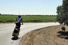
505. Not much out here but open fields and orchards. After about 8
or 9 miles we hook up with the ACA route and are traveling East on Putah Creek
Road. The creek is off to our left and it meanders along. Sometimes
you are right next to it, others you are further away. We head under
Highway 505 and continue on our way. We're passing along open fields now
and what looks to have been a walnut orchard. I can tell by the cracked
walnut shells all over the road, no sight of the trees though, must have been
the end of the life of the orchard. In my mirror I see a number of
cyclists closing on us fast, it must be the welcoming committee. As they
pass by every other one tells us hi. I find out that they are part of the
Davis Cycling Club on a morning ride. The Davis Cycle Club is very large
and hosts a number of events during the year. I hope to go on one during 2006.
It
was 10:00 am by the time we were packed and ready to go. As I looked at
the hills from the front of the house you could see the fog just trying to come
up and over the hills of Vacaville. The morning was clear but you could
feel a bit of a breeze already. We started out making our way along a
number of small farm roads as we headed back to hook up with the ACA
route. We headed all the way over to the frontage road along Highway
505. Not much out here but open fields and orchards. After about 8
or 9 miles we hook up with the ACA route and are traveling East on Putah Creek
Road. The creek is off to our left and it meanders along. Sometimes
you are right next to it, others you are further away. We head under
Highway 505 and continue on our way. We're passing along open fields now
and what looks to have been a walnut orchard. I can tell by the cracked
walnut shells all over the road, no sight of the trees though, must have been
the end of the life of the orchard. In my mirror I see a number of
cyclists closing on us fast, it must be the welcoming committee. As they
pass by every other one tells us hi. I find out that they are part of the
Davis Cycling Club on a morning ride. The Davis Cycle Club is very large
and hosts a number of events during the year. I hope to go on one during 2006.
 Putah
Creek eventually ends at Stevenson Bridge Road. We make a left and head
across the creek. Once over the creek we take a right onto a bide trail
that parallels Russell Blvd. This Bike Trail will take us all the way into
Davis, about 4 miles away. The bike trail is a nice change from the farm
roads, not that they were bad, it's just nice to not to have to worry about
traffic. The closer to Davis we get the more cyclists we have coming from
the oncoming direction. People out for the day on a ride, people coming
from School, or just people riding around town. It's amazing how much this
trail is used. Soon we're at the end of the trail at the overpass for
Highway 113. We stop for the light and wait for cars to pass by.
Next we head over the freeway and are back on the road in the bike lanes.
Sometimes the lane will come onto a trail by it's self and then it will come
back onto the road as a lane. Either way you have lots of room as a
cyclist. The ACA Route has you continue on the bike trail into the UC
Davis Campus, we decided to just keep following Russell Blvd into town, Connie
had said it was confusing as you went through the Campus to know which trail to
really take. I wasn't that excited to see the campus so we decide to just
follow Russell. Near B Street we find a really nice park and decide to
stop for a break. They have a nice restroom and water fountain. It's
a good excuse for a 15 minute break.
Putah
Creek eventually ends at Stevenson Bridge Road. We make a left and head
across the creek. Once over the creek we take a right onto a bide trail
that parallels Russell Blvd. This Bike Trail will take us all the way into
Davis, about 4 miles away. The bike trail is a nice change from the farm
roads, not that they were bad, it's just nice to not to have to worry about
traffic. The closer to Davis we get the more cyclists we have coming from
the oncoming direction. People out for the day on a ride, people coming
from School, or just people riding around town. It's amazing how much this
trail is used. Soon we're at the end of the trail at the overpass for
Highway 113. We stop for the light and wait for cars to pass by.
Next we head over the freeway and are back on the road in the bike lanes.
Sometimes the lane will come onto a trail by it's self and then it will come
back onto the road as a lane. Either way you have lots of room as a
cyclist. The ACA Route has you continue on the bike trail into the UC
Davis Campus, we decided to just keep following Russell Blvd into town, Connie
had said it was confusing as you went through the Campus to know which trail to
really take. I wasn't that excited to see the campus so we decide to just
follow Russell. Near B Street we find a really nice park and decide to
stop for a break. They have a nice restroom and water fountain. It's
a good excuse for a 15 minute break.
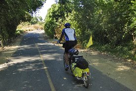
After our little break we continue on down 5th Street. Eventually we make a right turn and make our way over to Third Street we make a left and follow this down to L Street. Some of the streets are a little tight where you share the road with the cars, we were off the bike lane streets which made it a little tight. Once we were across the railroad tracks it was the industrial part of town. We followed the tracks around and then made our way over to Second Street. We would follow this all the way out of town. The wind had picked up now and would be a bit of a headwind. Nothing too bad, but it was wind in the face. We were making good time and since there was no climbing to contend with I was able to keep a much fast pace today than the previous couple of days. Most times I would look down and see that I was doing 15 to 16 mph.
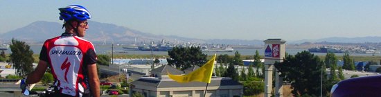
We made our way along the Frontage Road and eventually came to the entrance of the Yolo Causeway Bike Trail. This is the main connector from Downtown Sacramento to Davis for those that commute each day via bicycle. I had seen many a cyclist on this before since I've driven the Yolo Cause way countless times, but I had never before cycled across, this would be a new experience.
I took a few pictures at the top of the cause way and realized this wasn't going to be as fun as I wanted. The wind had picked up considerable and the fact that we were cycling right next to the oncoming traffic didn't help. You have a very large lane to cycle in that is separated with a large cement guardrail and fencing, so you don't need to worry about traffic coming into your lane. Instead you just need to worry about the trucks as they roar by and the onslaught of wind they will bring. It's actually not so much the wind as it is the dirt and grit that they kick up. As long as you have sun glasses on you'll be fine, just make sure you're mouth is closed.
The riding became a little slower here. But we made our way across. Connie soon became a dot in front of me as I was the only one loaded down, she only had a small backpack to carry her few belongings. Once on the other side of the causeway you make your way into West Sacramento. Here you'll find a heavy industrial area with a lot of trucks. You'll first need to make your way across to the other side of the road from where the trail ends at. Once on the other side you'll be heading down West Capitol Ave. There are a number of places to stop along the way here but we already knew where we wanted to go for lunch, Steamers in Old Sacramento.
It was now almost 1:00 pm and I was hungry. Once at the other end of West Capitol Avenue you will turn right onto 3rd Street, this will take you under a bridge, then you'll make a left hand turn onto South River Road. This will take you to the Capitol Mall where the Tower Bridge is, the edge of Old Town Sacramento. Most times you can ride your bike across the bridge because there is room, today they are doing construction and hold it down to only one lane. We are holding up traffic as we go across. As soon as we get across the bridge we make it back over to the sidewalk and walk our bikes across the cross walk. We make our way around the parking garage and along Front Street into Old Town. At the corner of Front Street and I think J Street you'll find the Steamers Coffee and Tea Exchange, it's actually a really nice Sandwich Shop with fancy coffee. We've been here many a time on our club rides. We pull our bikes up along the side of the store and go inside to get our sandwiches. They have a few tables and chairs outside and it was a plenty warm day to enjoy eating out doors.
It's 1:30 pm and we've made great time. We take about an hour to enjoy lunch and just sit and watch people walking by. A few look at my bike with the trailer but just don't know what to make of it. I'm surprised no one has asked we're I'm going or anything, maybe they don't understand the significance or care. At this point I don't' either, I'm almost home.
 I
walk across the street to get a few drinks for the ride home. I use the
restroom around the corner, nice flush toilets, head back and we mount up.
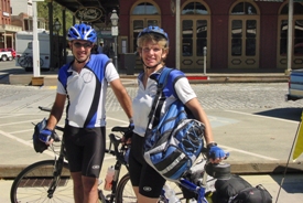
Across the street we decide to get once last picture of the two of us from a
couple of tourists. We find someone that actually knows something about
photography and takes a nice picture of use both. She would wait until the
car behind us passed by then zoom in and shoot. From this point on our
trip home would be uneventful, at least we hopped so, we had ridden this route
many times with the club and with each other. It was a favorite ride as we
went along the American River Bike trail, no cars, no stress, just riding
along. First we had to get out of Old Sacramento. We continued along
the trail by the Railway Museum and connect up with the American River Bike
trail. I don't think it is signed very well so unless you know what it
looks like you might have to ask a couple of people where it is. This will
take you along the Sacramento River and over to the park entrance of Discover
Park. You will then cross the old green painted bridge, either on the
street or the walkway. Not too many cars here. Once across the
bridge you find the trail at the bottom to the left.
I
walk across the street to get a few drinks for the ride home. I use the
restroom around the corner, nice flush toilets, head back and we mount up.
Across the street we decide to get once last picture of the two of us from a
couple of tourists. We find someone that actually knows something about
photography and takes a nice picture of use both. She would wait until the
car behind us passed by then zoom in and shoot. From this point on our
trip home would be uneventful, at least we hopped so, we had ridden this route
many times with the club and with each other. It was a favorite ride as we
went along the American River Bike trail, no cars, no stress, just riding
along. First we had to get out of Old Sacramento. We continued along
the trail by the Railway Museum and connect up with the American River Bike
trail. I don't think it is signed very well so unless you know what it
looks like you might have to ask a couple of people where it is. This will
take you along the Sacramento River and over to the park entrance of Discover
Park. You will then cross the old green painted bridge, either on the
street or the walkway. Not too many cars here. Once across the
bridge you find the trail at the bottom to the left.
 You
will then wind around under the bridge and continue along with the American
River now on your right. We followed along the trail for about 3 miles and
then made a quick left hand turn onto the Sacramento North Loop Trail.
This will take us home. The North Loop trail goes from the American Bike
Trail here all the way to Rio Linda, about 20 miles in all. We will take
it from here all the way to Elkhorn. This portion of the trail is nice as
it has a nice smooth pavement. Next the trail will take you through the
Del Paso Heights area. Be sure you're with someone and never at dark, it
can get rough in this area sometimes. The wind is still pretty strong as
we come out of town and are back into the open fields. It's now after 2:00
pm and home is beginning to sound really good. Soon we find ourselves
standing at Elkhorn Blvd. The decision is whether or not to continue up
the trail or go down Elkhorn, Connie would rather stick to the trail while I
want to go down Elkhorn, I prefer the wide lanes on Elkhorn and don't mind the
traffic, Connie likes the trail and the little farm roads. It's decided to
go down Elkhorn, for once I wish we would have went her way. About halfway
down Elkhorn they have it ripped up for installing water mains. It is not
signed that the bike lane is closed ahead, it's just got cement dividers in the
way putting you in the same lane as the cars and no signs. We make our way
over to the other side of the street and just ride against traffic, there is no
room otherwise on the correct side. We were too far down the road to turn
back to the trail. It lasted like that for about a mile. Finally we
find a street to detour on and took 28 street. We followed that all the
way over to Watt Ave.
You
will then wind around under the bridge and continue along with the American
River now on your right. We followed along the trail for about 3 miles and
then made a quick left hand turn onto the Sacramento North Loop Trail.
This will take us home. The North Loop trail goes from the American Bike
Trail here all the way to Rio Linda, about 20 miles in all. We will take
it from here all the way to Elkhorn. This portion of the trail is nice as
it has a nice smooth pavement. Next the trail will take you through the
Del Paso Heights area. Be sure you're with someone and never at dark, it
can get rough in this area sometimes. The wind is still pretty strong as
we come out of town and are back into the open fields. It's now after 2:00
pm and home is beginning to sound really good. Soon we find ourselves
standing at Elkhorn Blvd. The decision is whether or not to continue up
the trail or go down Elkhorn, Connie would rather stick to the trail while I
want to go down Elkhorn, I prefer the wide lanes on Elkhorn and don't mind the
traffic, Connie likes the trail and the little farm roads. It's decided to
go down Elkhorn, for once I wish we would have went her way. About halfway
down Elkhorn they have it ripped up for installing water mains. It is not
signed that the bike lane is closed ahead, it's just got cement dividers in the
way putting you in the same lane as the cars and no signs. We make our way
over to the other side of the street and just ride against traffic, there is no
room otherwise on the correct side. We were too far down the road to turn
back to the trail. It lasted like that for about a mile. Finally we
find a street to detour on and took 28 street. We followed that all the
way over to Watt Ave.
 As
soon as we hit Watt Avenue we made our way down to Elverta Road and took a
right. Next we follow Elverta over to North Loop and then make a left on
Walerga, we're in the Home stretch. The wind has continue and it is now at
our backs pushing us homeward. It's hard to believe I'm almost home.
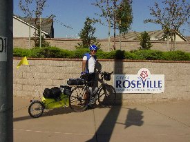
We make it all the way to the end of Walerga and it is here that we decide to
take the ceremonial picture to show the concluding photo. I had thought
about it for a bit, not wanting to just take a picture in front of my
house. Then it hit me, take a picture if front of the City of Roseville
sign. And so as we made our way across the busy Street of Baseline I lined
up the bike and the trailer while Connie found the best angle to shoot
from. The only problem was the utility pole right on the corner. She
just couldn't get around it. After taking a picture or two and watch
drivers go by looking in a weird stare we continued on.
As
soon as we hit Watt Avenue we made our way down to Elverta Road and took a
right. Next we follow Elverta over to North Loop and then make a left on
Walerga, we're in the Home stretch. The wind has continue and it is now at
our backs pushing us homeward. It's hard to believe I'm almost home.
We make it all the way to the end of Walerga and it is here that we decide to
take the ceremonial picture to show the concluding photo. I had thought
about it for a bit, not wanting to just take a picture in front of my
house. Then it hit me, take a picture if front of the City of Roseville
sign. And so as we made our way across the busy Street of Baseline I lined
up the bike and the trailer while Connie found the best angle to shoot
from. The only problem was the utility pole right on the corner. She
just couldn't get around it. After taking a picture or two and watch
drivers go by looking in a weird stare we continued on.
Down Baseline to the Junction Street intersection. I crossed the street and we headed down Junction for home. I was feeling it more now than ever, home was just around the corner, it was going to be nice to get in that shower, and most of all back in my own bed. I couldn't wait to see my wife and sons. Park Regency, right turn, Grouse Run, left turn, Killdeer, righ turn, up the drive way, I'm home!
I rode all the way up to the door and rang the doorbell, I didn't have my keys with me. It took about two minutes for someone to come to the door, my oldest son opened the door and just looked at me like, yes can I help you? Yeah it's me your dad remember? Good to see you can you please open the garage. It's good to be home.
|
Daily Stats |
|
| Rider: Devin Holmes Time Left: 10:00 am Time Arrived: 4:15 pm Max mph: 26.3 mph Avg mph: 13.4 mph Distance: 59.81 mi Actual Time Riding: 4:27:03 Elevation Climbed: 441 ft |
Camp Fee: $0 Shower: $0 Snacks: $5 Ferry: $0 Lunch: $7 Dinner:$0 Laundry: $0 Total Cost for today: $12 |
Copyright © 2003-2013 Devin Holmes