Links and More Home
My Equipment
My Links
My Photos
My Training
My Tours
My Trips
Last year I was able to successfully ride from Portland, OR to Fort Bragg, CA. Before I was even done with the trip I was already thinking of what was next. It didn't take long to figure it out, SF to the Border! So this year I will be riding from the Golden Gate Bridge all the way to the Mexican Border.
The Route
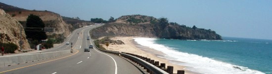
Once again I will be following the well established Pacific Coast Route. This is well documented in the Pacific Coast Bicycle Guide as well as the maps by Adventure Cycling Association. I have used both in the past and each one highlights key pieces that complement each other. Together you get all the options you need. After cycling the Northern portion of California and most all of Oregon this will be a nice route to finish up.
The Destinations
The further south you go in California the fewer options you have for camping out. So some of the legs of this trip will have days that are a little longer than what I've done in the past. The Pacific Coast Book has some lengths that are on the small side because of the touristy sites to see, I have been to many of these sites and don't care much to see them on this trip so I've made my own stops. Here is what I have:
- San Francisco to Half Moon Bay = 40
- Half Moon Bay to Sunset State Beach = 66
- Sunset State Beach to Pfeiffer Big Sur = 62
- Pfeiffer Big Sur to San Simeon State Beach = 52
- San Simeon State Beach Pismo State Beach: North Beach = 52
- Pismo State Beach: North Beach to Refugio = 70
- Refugio to McGrath = 65 McGrath to Redondo = 65
- Redondo to San Elijo State Beach = 80
- San Elijo State Beach to Chula Vista KOA = 45
This gives a total of 597 miles.
Due to the fires I had to change our route. When we left town on July 11th the hills around Big Sur were on fire. Everyone I talked with had told me that Highway 1 would be shut down until the end of July. With that I came up with a route that would take us inland through the Salinas Valley, all the way down to Paso Robles, and then take Highway 46 back over to Cambria. A detour that would add 50 miles over two days, but it would get us around the fire area and back onto the coast.
The Equipment
Not much will need to be changed here. I will need to give the Bike a good overhaul since it now has some miles on it. The back rim looks like it needs to be swapped out for a new one. I think it's been hit one too many times. I will definately go with the regular bike shoes again. That was great last time to be able to use those everyday, made a huge difference. The tent is still doing well. I really got a good by with that one. I just hope I don't have to rely upon it's water proof qualities, I want the beautiful sunshine this time around.
Menu
I struggled with this a bit last time but feel better this time around. Now that I've been out there and see what is available at stores on the road it's much easier to just go with it. I have been playing around a bit with the camping stove on weekend campouts to try out other meals that I can cook on the road. One of the things I really missed last time was having pancakes each day. So I've been testing out the little cooking stove with a small pan to see if I can get the same as I make at home, I'm getting there.
Maps
Once again I'll be using the Book and the Maps. Tried and true, the best.
Getting there and back.
Last time around I had a lot of logistics to figure out for getting there. This time around it's not so much. The more difficult part is getting home. I went through the same logistics for getting home to see what it would cost, bus, train, and airplane. Each had their pluses and minuses. But what I came down to this time was just rent a car and drive home, it will be easier and cheaper in the long run. So I will have someone drive me to my starting point and then once I finish at the end I will just drive home via one way rental.
A word about one way rentals. Most of the one way rentals are from Airports. Meaning there are a number of rental car companies in my home town, but I can't do a one way rental to them, only to the nearest airport. For me that is Sacramento International, about 20 minutes away, so that will work fine. Plus the fee is a bit more. Instead of a low daily rental fee of $30 or $40 it is a fee of about $115 per day. But it gets me home.
Camping Sites
I've had to pay closer attention to detail with the camping sites than before. A number of the campsites south of Monterey either don't have showers, don't have a hiker/biker site, or something else crazy about them that you need to be aware of. So due to this I have had to make some reservations and find alternatives. Here are some of the specifics that I found that you might find helpful:
- Kirk Creek - has now showers.
- Pismo - despite what the Pacific Coast Book tells you Pismo no longer has hiker/biker sites. I called to verify and as of March 2008 they do not. You need to make a reservation for a regular campsite if you want to stay here. There are other options like a local RV park.
- Hostels - Once you get to LA the book has you use two different hostels. Both of which are busy places. I've ready good and bad about them on the web. I decided to just find a friend in the area and stay with them.
I would suggest that you call each campsite you plan on staying to verify they still have a hiker/biker site and showers. I spent about 30 minutes and called all the potential sites and feel much better after having done so.

Copyright © 2003-2013 Devin Holmes