Links and More Home
My Equipment
My Links
My Photos
My Training
My Tours
My Trips
Saturday 08/21/04
 5:15
am - Once again I found myself waking up early on a Saturday morning.
Usually early for me is 8:00 am, today it is 5:15 am. We arrived the night
before to stay in the town of Camarillo, CA. It's just east of Ventura
where we are to start our next cycling adventure.
5:15
am - Once again I found myself waking up early on a Saturday morning.
Usually early for me is 8:00 am, today it is 5:15 am. We arrived the night
before to stay in the town of Camarillo, CA. It's just east of Ventura
where we are to start our next cycling adventure.
I shave, shower, dress, and we load up our gear. We arrived at the Four Points Sheraton and once again are amazed by the mass of cyclists just like us. We've already checked in having visited the hotel the night before so we already have our maps, bib number, and are ready to go. After talking about the routes we checked our watches, talked about the rest stops, and headed out. Official start time is 6:30 am.
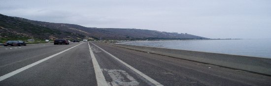
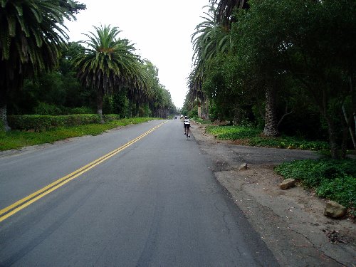
The morning is cool, but not cold. I had debated whether or not to wear a heavier shirt, wind breaker, or even long pants. After a couple of miles I'm fine and plenty warm. It's overcast and gray leaving everything in an early morning slumber. We're meandering through houses tucked neatly in together in the West Harbor area. After a couple of turns we make our way in the Business District and soon arrows point in opposite directions. The bright orange, Double-Metric Century, is pointing me straight ahead. The green, Metric Century, heads off to the left. I wish my Dad farewell and good luck. There are a few riders in our group, all of them head off to the left as well. I head straight on through the light and find myself alone. Soon I am on a nice bike trail that is heading up an ever so slight grade, not much, but you can tell you are going up. The trail is going through the industrial part of town with mountains on either side.
At the end of the bike trail I head across a bridge and wind around through a number of streets with houses dotted along the way. It's definitely not the suburbs. A few cyclists have passed me up now and I've grouped in with a couple of riders as well. the hills begin to head up and soon we are climbing. The grade is between 3% - 6%, nothing too steep but it makes for a good workout.
As I head up the hills
there's not much out here. The land is golden brown and the roads have
been fairly descent, bike lanes are good but I'm ready for a rest stop.
Somewhere in the next couple of miles it's waiting for us.
|
Rest Stop #1 Stats |
|
Max mph: 29.5 Avg mph: 14.9 Distance: 21.18 Actual Time Riding: 1:24:55 Elevation Climbed: 790 |
8:15 am - Finally around mile 21 it's here. I pull off into the CDF Fire Station and find a tiny group of cyclists, about 25 in all. These are the few that have elected to go beyond the usual 100 miles and push to 120 miles. There is plenty to choose from at the snack table. I fill up on lemonade, trail mix, a quick peanut butter & jelly sandwich and then it's back on the road.
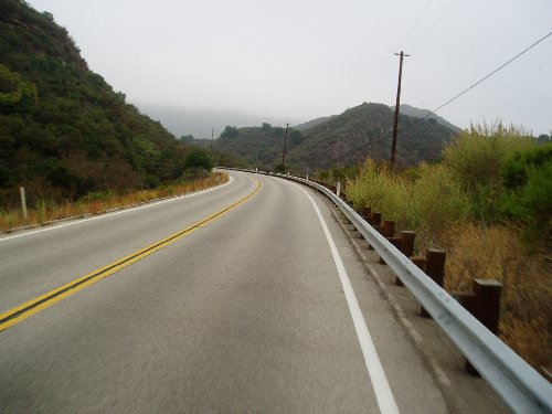 The
next stretch of road is the single longest point on the route where we didn't
have to turn, 12.5 miles. I'm not sure if that's good or not. The
climbing is getting a little more difficult as we head up to Casitas Pass.
I watch my Elevation continue to go up. I'm hoping to get a picture of the
Sign marking the top of the Pass but it's not marked like other mountain
passes. Maybe next time. It's still overcast but there is no wind to be
felt, that's a good thing. After the pass we start to have a nice
descent. I watch my speed. I don't want to have an early end.
There are some cyclists that just fly by with no care in the world. We are
now on Highway 192 and heading into the orchards; avocados, citrus, and lots of
other trees along the hillsides. The hills are not as barren and brown any
more. Instead it is very lush and beautiful. The road is getting
smaller and smaller. We are now on some roads that are about one and a
half car lanes wide. No cars to be seen. Coming from the opposite
direction is a constant stream of cyclists. I'm trying to figure out if
they are on a separate ride or part of ours, no bib numbers to be
seen.
The
next stretch of road is the single longest point on the route where we didn't
have to turn, 12.5 miles. I'm not sure if that's good or not. The
climbing is getting a little more difficult as we head up to Casitas Pass.
I watch my Elevation continue to go up. I'm hoping to get a picture of the
Sign marking the top of the Pass but it's not marked like other mountain
passes. Maybe next time. It's still overcast but there is no wind to be
felt, that's a good thing. After the pass we start to have a nice
descent. I watch my speed. I don't want to have an early end.
There are some cyclists that just fly by with no care in the world. We are
now on Highway 192 and heading into the orchards; avocados, citrus, and lots of
other trees along the hillsides. The hills are not as barren and brown any
more. Instead it is very lush and beautiful. The road is getting
smaller and smaller. We are now on some roads that are about one and a
half car lanes wide. No cars to be seen. Coming from the opposite
direction is a constant stream of cyclists. I'm trying to figure out if
they are on a separate ride or part of ours, no bib numbers to be
seen.
My average has started to
drop but I feel I am still doing well and should finish in time. I've
already been cycling for 3 hours and feel good despite the climbing that I've
already done. I try not to push to hard but I need to keep going at a good
pace. We now meet up with the other routes. The Double-Metric
basically did a big loop up into the hills and then came back down to meet up
with the other routes. A number of us came down out of the hills all at
the same time and merged in with a huge crowd. There are riders in front
and in back as far as I can see. We follow the same route for about 5
miles and then the Orange route breaks off again. Well so much for being a part
of the group. After another five miles we're back on the same route as the
others and then we arrive at the next rest stop.
|
Rest Stop #2 Stats |
|
Max mph: 35.7 Avg mph: 14.5 Distance: 44.91 Actual Time Riding: 3:05:14 Elevation Climbed: 2,692 |
10:20 - At Rest Stop #2 I check my stats and see that I've climbing 2,000 feet in the last 24 miles. I've already climbed half of the elevation that will be on the route. My average mileage has dropped but that's okay I'm still doing fine. This is one of the main rest stops for the day so there are lot's of people here. I wander around looking for my Dad thinking he might be here. I soon give up looking for him and instead fill up on liquids and get more snacks for the ride. Instead of finding my Dad I do find Brent Kingsford and compare notes with him on the Metric Century. He's here with his daughter on the tandem he recently purchased and they are having a great time. I also meet Brent's parents who are riding the Metric Century route. After a quick bathroom break it's back on the road.
Leaving rest stop #2 Orange goes right, everyone else goes left. We are now climbing into the hills above Carpinteria and heading North West for the Santa Barbara Hills. The houses here are huge and very secluded. Most have gated driveways and some of the streets are lined with palm trees. The climbing is getting harder as we go along. I think this is worse than the pass was earlier in the day. We make our way up and around a number of the hills. There are no bike lanes now and we have to be careful with cars coming in direction. As I come down one hill and go into a tight turn I hit a bump and one of my bottles bounces out. I'm doing 30 miles an hour when it does this, I keep on going with two other bottles left.
It's 11:30 now and the weather is getting warmer, still no sun but definitely warmer. I listen to my MP3 player every now and then but tire of it easily. I actually enjoy listening to the sounds around me more than the music. Speaking of sounds, smells are a big part of the cycling experience. It's amazing how much you miss when you are driving along. Earlier in the day I rode right next to a water treatment plant, that seemed to last forever. Going through the orchards have some very strong smells as well, love that citrus.
We've dropped down out of the hills and are making our way through Santa Barbara. We are back on the main route that everyone else is taking. I soon realize that all of the cyclists that are on the other side of the road are heading back to Ventura since they have already been to the lunch stop. At mile 67 I reach a personal milestone, every mile past this point is my new record for total miles in one day. It's hard to believe that I still have another 55 miles to go before I make it back.
Once again we break
off from the same route as everyone else and make a big loop around the back
side of Santa Barbara before we meet up at Stove Grove Park Rest Stop #3.
Somewhere along the way a cyclists asks me if I am on the regular century or the
Double-Metric. He got confused and wasn't sure which route he was
on. He wasn't too happy when I told him which one he was one. Soon
enough it was lunch time.
|
Rest Stop #3 Stats |
|
Max mph: 35.7 Avg mph: 14.2 Distance: 71.19 Actual Time Riding: 4:59:10 Elevation Climbed: 4,073 |
 12:30
- I'm more than half way. However I'm worried now that I'm not going to
make it back in time. I look at the routes and realize that the rest of
the way back is the same as everyone else so I can't just hop onto another route
to try and cut off a few miles. I've gone past the point of no
return. I've already done the extra miles of the Orange Loop. I
decide not to think about it anymore and just get some lunch.
12:30
- I'm more than half way. However I'm worried now that I'm not going to
make it back in time. I look at the routes and realize that the rest of
the way back is the same as everyone else so I can't just hop onto another route
to try and cut off a few miles. I've gone past the point of no
return. I've already done the extra miles of the Orange Loop. I
decide not to think about it anymore and just get some lunch.
You can tell that the majority of the group has been here, the trash cans are over flowing, and the lunch tables have been wells used. However there is still plenty to eat and the staff are taking good care of us. Making sure we have enough to eat, drink, and asking if we need anything.
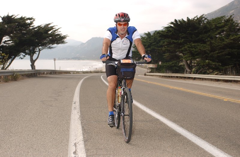
Before the trip I was debating on which Jersey to wear, sounds stupid I know but I wanted to be in a different jersey than the other rides I've done this year for my picture. I know sounds really dumb. I brought two shirts, my Fisheous Jersey and the Church Bike Club Jersey. I finally decided to use the Bike Club Jersey as we packed up our gear this morning. Well when I sat down at lunch I had only been sitting there a couple of minutes when I guy sits down next to me wearing a Fisheous Jersey, I'm glad I didn't wear that Jersey today. I know it's stupid.
I didn't want to take too much time for lunch but I really needed a break. Despite my average miles per hour dropping a hair I've been pushing pretty hard. I've been pleased with my performance thus far. The bike has been flawless, no flats, no problems at all, except for the water bottle bouncing out. As on other trips I've seen the usual road bike on the side of the ride with the owner repairing a flat. I like my armadillo tires!
Lunch was comprised of making your own deli sandwich, chips, cookies, and all you could drink lemonade and water. The sandwiches were good, but you had to be careful not to eat too much. Believe me I was ready for another after the morning ride. But it was time to get going again.
 01:00
pm - Back on the road. The route is different than how we got to the
park. We're are cutting our way back through over to the Coast.
Traffic is getting heavier now that we are heading to were all of the crowds
are. Up until this point there hasn't been much traffic to contend
with. We are now riding right along the coast, it's still overcast but
warm enough to have fun on the beach. Others are out cycling and look over
at us as we move on through at a quick pace. We are now heading back up
through the exclusive housing areas of Santa Barbara, I'm still amazed at all of
the houses that are built on the side of the hills. There is a change for
me to take a couple of picture of the houses. I've not been able to take
as many pictures on this trip as I would have liked to. Too much climbing
to working about and then once you get to the top you are flying down the
hill. Many times I've been taking pictures at a light when I'm stopped or
just when I'm cycling along. The riding is strenuous again as we are going
up and down hills. I'm passing other cyclists now. You can tell
which ones are on the Metric Route versus the Double-Metric.
01:00
pm - Back on the road. The route is different than how we got to the
park. We're are cutting our way back through over to the Coast.
Traffic is getting heavier now that we are heading to were all of the crowds
are. Up until this point there hasn't been much traffic to contend
with. We are now riding right along the coast, it's still overcast but
warm enough to have fun on the beach. Others are out cycling and look over
at us as we move on through at a quick pace. We are now heading back up
through the exclusive housing areas of Santa Barbara, I'm still amazed at all of
the houses that are built on the side of the hills. There is a change for
me to take a couple of picture of the houses. I've not been able to take
as many pictures on this trip as I would have liked to. Too much climbing
to working about and then once you get to the top you are flying down the
hill. Many times I've been taking pictures at a light when I'm stopped or
just when I'm cycling along. The riding is strenuous again as we are going
up and down hills. I'm passing other cyclists now. You can tell
which ones are on the Metric Route versus the Double-Metric.
As
we cruise along through the outskirts of Santa Barbara I hear what sounds like
gunfire. I look straight ahead and see a puff of smoke coming from the
back tire of the Woman riding in front of me. Looks like her whole valve
stem just popped right off, scared the heck out of all of us around her.
Her husband was about a 100 feet in front, I knew this because they were both
wearing Google Jerseys and I talked with them at Lunch, I let him know what had
happened. Hopefully they have a spare tube or they'll be waiting for the
Sag Wagon. Soon I'm at Manning Park again for Rest Stop #4.
|
Rest Stop #4 Stats |
|
Max mph: 35.7 Avg mph: 14.1 Distance: 91.64 Actual Time Riding: 6:27:46 Elevation Climbed: 4,898 |
2:40 - Once again you can tell that everyone else has already been here. The snacks are fewer than they were this morning. However there is still plenty to choose from. There are only about 30 to 40 cyclists here. They are either people that got a really late start on one of the routes this morning or they are on the Double-Metric, you can tell who is which. My Average miles has dropped again due to the climbing that we just did. I'm surprised that my average hasn't increased, at least I'm still going.
As we pull out of Manning Park and head for Rest Stop #5 there are fewer along the way. The Sag Vehicle has passed us a number of times in the last hour. I think they are making sure there are no other stragglers previous to Manning Park. I'm still doing numbers in my head to see what time I'm going to finish. I'm confident now that I'll finish right about 5:00 pm, much better than the 6:00 pm time that I came up with earlier in the day.
As
we head through the town of Carpinteria, I look up into the hills and try to
figure where we were riding earlier. We head up and over Highway 101 then
we are actually on the Freeway to the next exit of Bates Road, rest stop #5.
|
Rest Stop #5 Stats |
|
Max mph: 35.7 Avg mph: 14.1 Distance: 103.05 Actual Time Riding: 7:16:56 Elevation Climbed: 5,379 |
 3:40
- One of the things they had advertised on the website about the Cool Breeze
ride was that they would have Popsicles at the last rest stop. While it
wasn't 100 degrees out it was still warm enough that a Popsicle was very
nice. There were the same 30 or so cyclists here that I had seen at the
previous rest stop. I decided that I wasn't going to stay here long, I
wanted to get back on the road to finish up. Filled up with Lemonade and
headed back out.
3:40
- One of the things they had advertised on the website about the Cool Breeze
ride was that they would have Popsicles at the last rest stop. While it
wasn't 100 degrees out it was still warm enough that a Popsicle was very
nice. There were the same 30 or so cyclists here that I had seen at the
previous rest stop. I decided that I wasn't going to stay here long, I
wanted to get back on the road to finish up. Filled up with Lemonade and
headed back out.
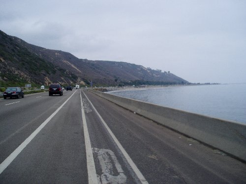
After this rest stop you actually get back on the Highway and ride with the cars. It was a new experience for me as I cruised along on Highway 101. To the left were cars, to the right was a beautiful view of the ocean. I'm sure there are times when riding along on this stretch it is quite windy, but today there is none to complain about, it's merely a Cool Breeze.
I'm moving pretty fast now, around 18 to 20 mph. The peninsula up ahead is hiding Ventura, it's just around the corner. As I ride along I can see people don't at the waters edge enjoying the day playing in the surf and sand. After 5 miles I exit the freeway and ride along the old Pacific Coast Highway. Along here is one big row of RV, Trailers, and Campers. You are able to park your RV and stay overnight. It's a self pay site area. It's quite the interesting assortment of vehicles. It goes on for at least a mile.
Finally I pass the photographer at 4:25 pm. He had been taking pictures at the entrance to Emma Woods all day long. The Double-Metric Century didn't go pass that area until the end of the ride. It was mile 114 when I passed him, hopefully I don't look too pathetic.
I'm on the home stretch now. One more bike trail and then it's back through the little shops and houses of Ventura Harbor. A number of us have grouped together because of all of the stop lights and stop signs. I'm anxious to finish. I still can't believe I've ridden as far as I have. We pass by the boats and make a left turn towards the hotel. I come around the corner and there are people lined up and down both sides cheering on their friends and everyone else that comes in.
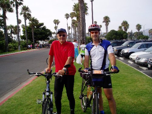 4:55
pm - "I made it," that was my exact thought as I pulled up to the
Hotel and saw my dad sitting under a palm tree enjoying the afternoon sun.
I got off my bike and actually had a big smile. I was smiling because I
had accomplished a huge milestone, I've never ridden that far in one day.
I found someone sitting nearby and asked them to take the ceremonial picture of
my dad and me. Once again another route completed with no problems.
I asked what they were serving for the after ride meal, spaghetti, no thanks,
let's go get some real food.
4:55
pm - "I made it," that was my exact thought as I pulled up to the
Hotel and saw my dad sitting under a palm tree enjoying the afternoon sun.
I got off my bike and actually had a big smile. I was smiling because I
had accomplished a huge milestone, I've never ridden that far in one day.
I found someone sitting nearby and asked them to take the ceremonial picture of
my dad and me. Once again another route completed with no problems.
I asked what they were serving for the after ride meal, spaghetti, no thanks,
let's go get some real food.
Overall I really enjoyed this trip and will probably do it again next year. Southern California has so many events all summer long. That is the one thing Sacramento is missing. Or course that is probably due to the heat he have. I did like this ride and the help from all of the volunteers. I know a lot went into putting this event on. Once again it was great to be a part of something and surrounded by those that enjoyed the same thing with the same type of passion. We probably would have stuck around for the after ride meal if it wasn't for the fact that we were heading up to Visalia that night, a 4 hours car ride. My only disappointment was that I didn't take enough pictures, but I was so worried about just finishing the course that it wasn't until the afternoon that I really started to take any pictures.
The route sheet that I have below is not 100% accurate. By the time we hit the first rest stop it was already 1.5 miles off. Then by the 2nd Rest Stop I only showed 45 miles while the route sheet showed 49 miles. I was worried that it was just me, but I heard a couple other people discussing the same thing, and they were also about 3 to 4 miles off what the route sheet said. Minor details, as long as the right roads are there. Otherwise the route was clearly marked all along the way. Lots of orange arrows.
|
Final Stats |
|
| Rider: Devin Holmes Max mph: 35.7 Avg mph: 14.3 Distance: 121.39 Actual Time Riding: 8:27:10 Elevation Climbed: 5,558 |
Rider: Dan Holmes Max mph: 36.9 Avg mph: 15.2 Distance: 64.08 Actual Time Riding: 4:11:27 Approx. Elevation Climbed: 1,400 |
| Cool Breeze Double-Metric Century Route (was painted orange) | ||
| Start - Harbor Town | 49.1 - R - Santa Rosa Lane | 94.4 - L - Santa Rosa |
| 0.0 - L - Schooner Drive | 49.1 - R - San Ysidro | 94.5 - R - Santa Rosa |
| 0.1 - R - Anchors Way | 49.8 - L - East Mountain Dr. | 95.1 - L - San Leandro |
| 0.9 - L - Seaview Av | 55.8 - - Become Mountain | 95.9 - R - Sheffield Dr. |
| 1.2 - L - Oyster St | 56.1 - R - Mission Ridge | 96.0 - L - Ortega Hill |
| 1.3 - R - Seahorse | 56.4 - R - Hwy 192 | 96.8 - becomes Via Real |
| 1.5 - L - Penninsula St. | 60.3 - - Becomes Cathedral Oaks | 98.1 - R - Padarao Ln over fwy |
| 1.8 - R - Pierpont Blvd | 65.6 - L - Los Carneros | 100.1 - under fwy to T |
| 2.6 - R - San Pedro St. | 66.9 - R - Hollister Ave | 100.2 - R - Via Real |
| 2.8 - L - Harbor Blvd | 69.6 - R - over Frwy | 101.8 - R - Snata Ynez over fwy |
| 4.4 - R - Figueroa St | 69.7 - R - Calle Real | 102.0 - L - Carpinteria Ave through town |
| 4.5 - L - Thompson Blvd/Garden St. | 69.9 - L - Cathedral Oaks | 104.8 - R - Hwy 101 onramp |
| 5.0 - L - Main St | 74.4 - R - La Patera | 105.8 - R - Bates Road Exit |
| 5.1 - R - Olive St | 74.5 - REST STOP #3 - Stow Grove Park | 106.1 - R - REST STOP #5 - Bates Road |
| 5.2 - L - Dubbers St | 74.5 - R - La Patera | 106.1 - L/R - Highway 101 South |
| 5.3 - L - Bike path (actually straight) | 74.6 - R - Cathedral Oaks | 110.5 - R - Seacliff Exit |
| 10.9 - L - Casitas Vista Rd (Foster Park) | 77.9 - R - Turnpike Rd | 110.8 - R - Old PCH |
| 11.6 - R - Santa Ana Rd | 79.0 - L - Hollister | 117.1 - R - Bike Path don't enter freeway |
| 15.6 - R - Burnham Rd | 80.1 - R - Modoc | 118.5 - R - Main St. |
| 17.6 - L - Highway 150 | 81.1 - R - Las Palmas Dr./Roble Dr | 119.1 - R - Olive St. |
| 22.5 - R - REST STOP #1 CDF Fire Station | R - becomes Marina/Cliff Dr. | 119.2 - L - Santa Clara St. |
| 22.5 - R - Highway 150 | 86.7 - R - Meigs/Shoreline/Cabrillo | 119.6 - R - Figuerora St. under fwy |
| 34.8 - R - Gobernador Cyn Rd | 91.4 - R - Channel Dr (becomes bike path) | 119.8 - L - Harbor Blvd. |
| 37.6 - R - Foothill/Hwy 192 | 92.9 - R - Danielson/S Jameson | 121.4 - R - San Pedro St. |
| 39.6 - R - Linden/Foothill/Hwy 192 | 93.5 - R - San Ysidro | 121.5 - L - Pierpont Blvd. |
| 42.5 - R - Nidever/Foothill/Hwy192 | 94.4 - R - Santa Rosa Ln | 122.3 - L - Peninsula St. |
| 44.0 - R - Toro Canyon Rd/E Valley Rd | 94.4 - REST STOP #4 - Manning Park | 122.6 - R - Seahorse Ave |
| 46.4 - L - Sheffield Dr | 122.8 - R - Beachmont / Anchors Way | |
| 47.6 - R - San Leandro Ln | 123.6 - L - Schooner Dr. | |
| 48.4 - L - Snata Rosa Ln | 123.7 - R - Parking Lot | |
| 49.0 - L Santa Rosa Ln | ||
| 49.0 - R - REST STOP #2 - Manning Park | ||
Copyright © 2003-2013 Devin Holmes