Links and More Home
My Equipment
My Links
My Photos
My Training
My Tours
My Trips
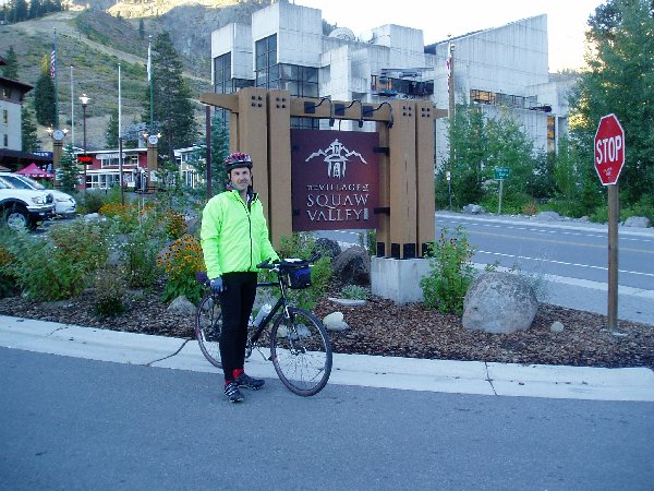
Friday 9/24/04
This would be the last major trip of the year. I was really looking forward to this. It would truly put to test all of the training I had done for the year. In the end it would test me not only physically but mentally.
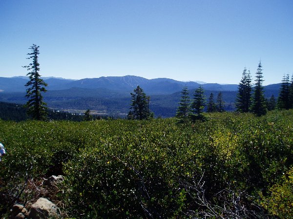
We arrived just before dusk Friday night and were able to set up camp rather fast. All we had to do was setup the tents and air mattresses. We had eaten on the way up so we didn’t have to worry about cooking dinner or anything. After sitting around the table talking and me writing in my journal it was time to turn in for the night. We could feel the temperature dropping rather fast but I felt we would be fairly warm in our sleeping bags.
I’ve always enjoyed camping, but I don’t think I’ve ever camped this late in the season at such a high elevation. I knew it would be a little on the cool side that night but I don’t think I realized how cold it would really be in the morning.
Saturday 9/25/05
 I
slept rather good considering we weren’t that far from the freeway but morning
came soon enough. I was up putting
things away at
I
slept rather good considering we weren’t that far from the freeway but morning
came soon enough. I was up putting
things away at
Soon we were packed and heading
to
The first thing I noticed as I
cycled along the road heading back towards SR89 was how flipping cold it was.
Even though I had long fingered gloves on they needed to be much thicker,
I have a pair at home. I had a
skull cap on under the helmet, that helped but my ears weren’t covered very
well. I had a regular jersey on,
then it was a heavy sweatshirt, then a windbreaker.
This was some very bad layering. Soon
I was feeling very moist inside all of these layers.
The sweatshirt kept me very warm but did nothing for letting all of the
heat escape. At this point I
didn’t care, it was too dang cold, only 37 F degrees.
As I followed along SR89 we came to a bike trail that we were able to
follow, it made cycling very easy. Soon
we were at the base of
About 18 miles into the course the trail went in front of a Convenience Shop, the trail was covered in pine needles, you wouldn’t think much of it, except for the fact that it made for a very slick trail. Someone must have made a bad turn or something and down they went. I came upon it shortly after it happened. A sheriff just happen to be out front and called for an Ambulance right away. The sheriff was concerned that a car had clipped the cyclist because he hadn’t seen what had happened. The guy was very disoriented, I remember the sheriff asking him questions, who are you, what are you doing, the answers weren’t that intelligible, he hit his head pretty good. Soon the EMT was there and getting him loaded up. I was only there 5 minutes just making adjustments to my bad pick of clothing.
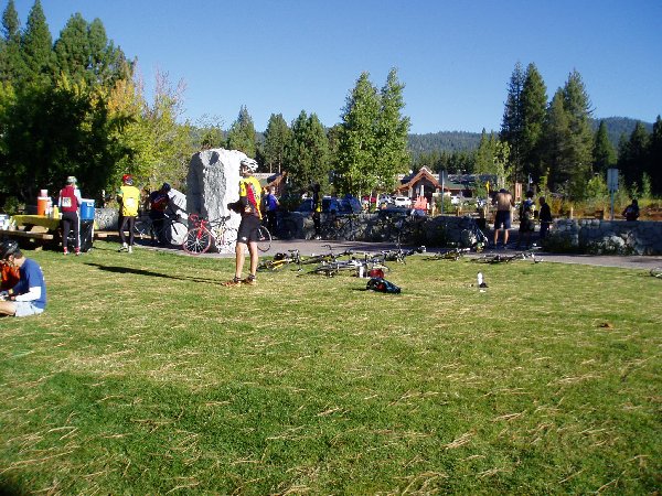
I made my way around the lake, a few up and down hills, nothing to strain at. Traffic was picking up and the morning was starting to come alive with travelers. Soon enough it was time for the first rest stop of the day at Kings Beach.
| Stats for Rest Stop #1: Max mph: 33.2 Avg mph: 14.7 Distance: 17.05 Actual Time Riding: 1:09:34 Elevation Climbed: 582 |
 The
first thing I did was take off my heavy layers.
Thankfully it was warm enough that I did not need the sweatshirt anymore.
At this rest stop they provided you with big bags to put unwanted
clothing in and they would have it waiting for you at the end of the course.
Next I put my windbreaker on the bike and spread it open in hopes of air
drying it a bit before I had to put it back on.
Then I made my way to the morning brunch they had lined up for us.
Lots of juice, muffins, fruits, and munchies.
Then it was a quick trip to the restroom and back on the trail.
There were at least 50 to 75 cyclists here.
A big group and it would be that way most of the day.
The
first thing I did was take off my heavy layers.
Thankfully it was warm enough that I did not need the sweatshirt anymore.
At this rest stop they provided you with big bags to put unwanted
clothing in and they would have it waiting for you at the end of the course.
Next I put my windbreaker on the bike and spread it open in hopes of air
drying it a bit before I had to put it back on.
Then I made my way to the morning brunch they had lined up for us.
Lots of juice, muffins, fruits, and munchies.
Then it was a quick trip to the restroom and back on the trail.
There were at least 50 to 75 cyclists here.
A big group and it would be that way most of the day.
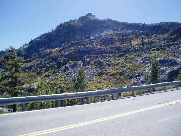
The trail headed north up SR267 to Brockway Summit. The climb would take me to just over 7,200 feet. As I made my way up the hill I remember Ram’s Horn Grade from the Sierra Century earlier in the year. But I hadn’t done much climbing like this since. I should have done more climbing. I made my way carefully up the slope doing about 6 to 9 mph. It was slow most of the way with everyone else going just about as slow. Some speed by but not too often. I had to stop near the top and take off my long tights, even though it wasn’t too warm, up to 60 F degrees now, I wasn’t able to cool down with these on. So I was now in my short sleeve jersey and cycling shorts. I would have never thought I be back in them after waking up this morning with near freezing temperatures.
Soon I was at the top and looking at the big yellow sign posted with a 9% grade going down. I was in for a real treat, speed. As I made my way down I tried to feather the brakes to keep it down around 32 to 35 mph. As I did so guys were just flying by me, doing at least 45 mph. I couldn’t imagine going that fast on such a small tire, not today. I soon passed North Star, a ski resort I’ve been too many times. It was just weird cycling by like this. Once over the summit I was down in the valley at the edge of Truckee. It would be a couple of miles to get back over to Interstate 80. I made my way going at a pretty good clip, then it was time to cross the Truckee River on the new bridge constructed in the last couple of years. This allowed you to get straight to I-80 without having to go through town. Once at I-80 we headed under the freeway and continued North on 89. This would take us over to the Prosser Reservoir Picnic Area. This is another area that I’ve been to many times as a kid and now as an adult scout leader. Why do I go here, Snow Camping. So it was very weird to see this area with no snow but I’m glad considering what I was wearing.
| Stats for Rest Stop #2 Max mph: 33.2 Avg mph: 14.3 Distance: 32.08 Actual Time Riding: 2:14:21 Elevation Climbed: 1,836 |
Rest Stop #2 wasn’t anything fancy but it was nice to have a chance to stop again. More of the same, liquids, snacks, energy bars, a mechanic to help out anyone needing it, and even a massage for those that have a knot that won’t go away. I didn’t spend much time here and soon I was back on the road heading up Elder Creek Way. The road was a gradual climb. No traffic at all, it seemed like the cyclists were becoming fewer and fewer. Soon we were in what seemed like a residential area, but it wasn’t, it was just a whole bunch of cabins. We made a turn near the top and were now on Ski Slope Way. This can’t be good. It wasn’t.
 The
climb continued to go up. On the
left I saw what I thought was a ski lift. Why
would you have a ski lift in the middle of all of these cabins.
Well turns out that there is a ski slope at the top that residents use
to go skiing, hence the name of the street.
Up and up we went. My average
was going down and down and soon I thought I heard bells, I couldn’t make it
out, maybe it was angels welcoming us to the top, no, it was the welcoming
committee at the top with cow bells cheering us to the top and then encouraging
us as we headed down the other side of Ski Slope Way. I just had to stop at the top,
what a view. The elevation was at
least 7,000 ft. You are at the top
of this area and can see all the way around looking at other ski resorts, hiking
trails, and lots of trees, it's just gorgeous. Okay moments over,
get moving.
The
climb continued to go up. On the
left I saw what I thought was a ski lift. Why
would you have a ski lift in the middle of all of these cabins.
Well turns out that there is a ski slope at the top that residents use
to go skiing, hence the name of the street.
Up and up we went. My average
was going down and down and soon I thought I heard bells, I couldn’t make it
out, maybe it was angels welcoming us to the top, no, it was the welcoming
committee at the top with cow bells cheering us to the top and then encouraging
us as we headed down the other side of Ski Slope Way. I just had to stop at the top,
what a view. The elevation was at
least 7,000 ft. You are at the top
of this area and can see all the way around looking at other ski resorts, hiking
trails, and lots of trees, it's just gorgeous. Okay moments over,
get moving.
Once again I found myself
feathering the brakes as I was being passed by cyclists that had no problem with
flying down the hill at 45 mph. Me on
the other hand I just didn’t want to worry so I kept at my slow pace of 35
mph. The only bad thing about this
type of descent is that they don’t last nearly as long as it took to get up.
Ten minutes later and we’re down at the bottom of the hill making our
way into Truckee and heading over to Donner
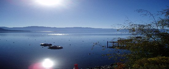
Once again an area that I’ve spent some time at as a kid and as an adult. Now it’s from a more different perspective, cycling along at 15 to 18 mph. You get to take in the sites, sounds, and smells of everything. It was great. The lake looked so peaceful. The route took us the entire length of the lake and put us at the Park where there is a beach front and a park, just in time for another break.
| Stats for Rest Stop #3: Max mph: 44.1 Avg mph: 12.8 Distance: 49.71 Actual Time Riding: 3:53:04 Elevation Climbed: 3,762 |
Rest Stop #3. I didn’t need much of a break but was ready for something to eat. I was ready for lunch but that wasn’t until the next rest stop. I ate a few energy bars, orange slices, filled up on liquids and headed back out.
This is were it became a test of endurance, will power, and strength. I began to calculate how many miles I’ve done, how long it took, what I had left, and how long it would take. I still should be able to finish okay, but it wasn’t clear.
After rest stop #3 the route
took you up and over Donner Pass, yes the infamous
I was doing okay at the beginning of the slope, but soon the climb became very steep and I was struggling to keep up a slow pace. I was stopping every quarter of a mile, resting for 5 minutes and then continue on. Part of the problem was that I’ve already climbed 3,500 ft, the other part would be that I’m ready for real food. I was making my way up. No one was passing me, I wasn’t passing anyone else. It was slow going, but I was still going. I can’t remember how many times I would calculate how much I’ve done, what was left, how long it would take. It was truly becoming a mind came, can I really make this, can I really finish, what the heck am I doing here.
 Then
the ultimate mind trick happened. I
was slowly making my way up around a switch back. I
could see the road wind up in front of me and then around to the left allowing
me to see what was on the other side of the canyon.
There parked on the road was an
Ambulance, a Highway Patrol Car and a County
Then
the ultimate mind trick happened. I
was slowly making my way up around a switch back. I
could see the road wind up in front of me and then around to the left allowing
me to see what was on the other side of the canyon.
There parked on the road was an
Ambulance, a Highway Patrol Car and a County
I remember wanting to finish and wanting to go back all in the same thought. Food was still about 5 to 10 miles away, I decided to just keep going. From this point on the road was more of a descent so it was much easier. I got a nice ride from the Pass all the way to down to Cisco Grove. About half way down I happen to pass my Dad and Connie. We all stopped and I told them about the dead guy. They had just had lunch and said the food was great. I continued down the road to the end turnaround at the campground entrance and then headed back up the road to Rest Stop #4, lunch.
| Stats for Rest Stop #4: Max mph: 44.1 Avg mph: 12.4 Distance: 68.25 Actual Time Riding: 5:23:58 Elevation Climbed: 5,036 |
It was now almost
Once I hit the road again one thing was becoming apparent, my left knee was starting to bother me and if I didn’t get some ibuprophen in me I wasn’t going to make it to the end. A cyclist that I had seen most of the day and chatted with was just up a head. I stopped and asked if he had anything for pain, he just happen to have some Tylenol, it wouldn’t take off all the pain, but it would help. As I came down old highway 40 I remember passing a little gas station. Hopefully they’ll have what I need to make it to the end.
I’m seeing fewer and fewer cyclist on the road. There is a group of two or three up ahead loading their bikes on an SUV. I guess they’re done for the day. That still leaves a group of about 20 behind me. I make my way to the gas station and buy some ibuprophen, Gatorade, down both items and hit the road again. The ride is going okay, I’m still doing calculations about every 15 minutes to see how my time and mileage are doing. Can I make it just keeps going through my mind. At this point it’s going to be at least 4:30 pm or 5:00 pm when I finish. A SAG Van passes me heading the other way. He’s equipped with radios from the look of all the antennae he’s got on the roof. About 15 minutes later he’s back and pulls over to the side in front of me. He asks how I’m doing and wants to know if I want a ride back. I find out that I am the last rider on the course. All of those back at the lunch stop called it quits there and either got picked up by friends or were sagged in to the finish. Once again I find myself in a position that I either had to head back or continue. I knew my way back but I didn’t want to be on my own out here in the mountains. I felt I could finish okay and told him that I really wanted to continue. He radioed ahead that I was continuing and urged me to keep up the pace. About 2 miles ahead was Donner pass, only this time I got to fly down it, and believe me I did. My maximum speed going down was 44 mph. Once again I had to feather the brakes to keep control, especially going into and out of the turns, but it was easy to just pick up speed on such a steep grade. Near the bottom a sign was posted “35 MPH Limit Radar enforced,” I think I was doing 42 when I plowed by this sign, one of these days I know I’m going to get a ticket. I slowed down since the last rest stop was just up ahead at the beach. I pulled in long enough to let the crew know I wasn’t in need of anything and continued on. They had already shut down the rest area but had a couple of people standing around waiting for something, maybe me I don’t know. Either way I kept going.
The next stretch was to follow along Donner Lake again. This was a nice break and was very flat compared to what I had just ridden. Once at the other end of the lake it was time to finish the home stretch back to Squaw Valley. I was now heading South on SR 89 again riding along the road we drove in that morning. There was a slight grade to it but I was able to keep moving around 15 mph. Up ahead is a cyclist and my goal is not to be the last one in. About every mile a Subaru SAG Wagon has been waiting for us. They’ve been collecting the signs that were posted each mile warning motorists that cyclists were out on the road. The people picking up the signs would wait until I passed by, pull the sign and then move ahead to the next sign. They would wave me on each time I approached with encouragement. Finally I had passed the lone cyclist in front of me. As I passed the Volunteer Staff waiting ahead I yelled I wasn’t last now. The sun was starting to set and the mountains were now casting their shade. Its amazing how much the temperature drops when the sun starts to hide.
We’ve made a right hand turn up Olympic Drive, It’s now the home stretch. I’ve passed up another cyclist ahead of me, I’m now 3rd to last.
It’s up ahead, the end, I’ve actually made it. I thought I could do it, but thinking it and actually doing it are two entirely different things. I see my Dad and Connie up a head out in front of the Ski Lodge. It’s 4:55 p.m. and I’m done for the day, I look down and it’s 98.5, just shy of 100 miles. I look at the map and it tells you that if you’re short of 100 to ride around the parking lot. The only riding I’m doing is to the car, I’m done. We ask someone near to take the ceremonial group picture and he head to the car.
Driving home we share our stories, thoughts, and feelings from the day’s ride. It’s amazing to us how much territory we covered today. All of us have a huge appreciation for the early settlers and what they had to do.
This was a great ride, well supported, well sagged, plenty of help, clearly marked, and a great day overall. The next time around I’ll probably only do the metric century. Then just maybe I’ll get to enjoy the after ride meal.
|
Final Stats |
||
| Rider: Connie Hathaway Max mph: 40.8 Avg mph: 12.4 Distance: 66.70 Actual Time Riding: 5:20:50 Elevation Climbed: 2,500 |
Rider: Devin Holmes Max mph: 44.1 Avg mph: 12.5 Distance: 98.95 Actual Time Riding: 7:55:00 Elevation Climbed: 6,848 |
Rider: Dan Holmes Max mph: 40.8 Avg mph: 12.4 Distance: 66.70 Actual Time Riding: 5:20:50 Elevation Climbed: 2,500 |
Copyright © 2003-2013 Devin Holmes